

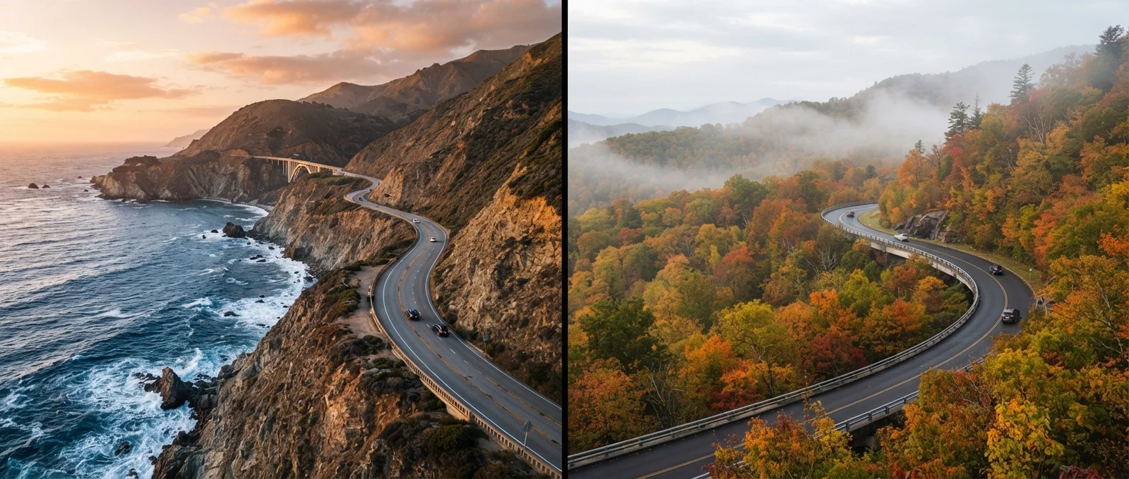
Key Takeaways
- PCH runs roughly 650 miles along the California coast; the Blue Ridge Parkway spans 469 miles through Virginia and North Carolina.
- PCH offers urban anchors like San Francisco, Big Sur, and Los Angeles; the Parkway is more rural with smaller gateway towns.
- Blue Ridge Parkway is a National Parkway with no commercial vehicles or tolls; PCH runs through state and local roads with typical traffic.
- Fall is the Blue Ridge Parkway's peak season; PCH is generally drivable year-round, though winter landslides can cause closures.
- Both routes reward slow travel — rushing either drive means missing the landscapes they're famous for.
Option A
Pacific Coast Highway (PCH)
The dramatic, ocean-hugging route along America's western edge.
Best for: Travelers seeking sweeping coastal views, diverse urban stops, and year-round accessibility along California's shoreline.
Option B
Blue Ridge Parkway
The serene, ridge-top corridor through the Southern Appalachians.
Best for: Travelers drawn to dense forest scenery, fall foliage, Appalachian culture, and a slower, unhurried pace.
If you want dramatic ocean scenery and major city access
Pacific Coast Highway (PCH)
PCH delivers consistent coastal panoramas and convenient urban stops in San Francisco, Monterey, Santa Barbara, and Los Angeles, giving you both nature and city flexibility.
If you prioritize fall foliage, forest immersion, and tranquility
Blue Ridge Parkway
The Parkway's ridge-top elevation produces stunning Appalachian hardwood color in October and November, with minimal commercial interruption and a genuinely unhurried atmosphere.
If you want the most accessible year-round road trip
Pacific Coast Highway (PCH)
California's mild climate keeps most of PCH open throughout the year, though travelers should always check for coastal highway closures before departing.
If you're interested in cultural heritage and Appalachian history
Blue Ridge Parkway
The Parkway corridor passes through Cherokee cultural landmarks, historic homesteads, and traditional craft communities not found on a coastal California drive.
Route Overview: Scale, Terrain, and Character
The Pacific Coast Highway — most commonly associated with California's Highway 1 — stretches approximately 650 miles along the state's coastline, from the Oregon border south toward the Los Angeles basin. It moves through redwood country in the north, hugs sheer cliffs above the Pacific at Big Sur, and passes through the beach communities of Santa Barbara and Malibu before reaching its southern extent. The driving is often technical: narrow lanes, hairpin turns, and no shoulder in places. That challenge is part of the appeal, but it demands attention.
The Blue Ridge Parkway covers 469 miles between Shenandoah National Park in Virginia and Great Smoky Mountains National Park in North Carolina. Administered by the National Park Service, the Parkway was designed specifically for recreational driving — no commercial trucks, no billboards, no intersecting freeways. Its maximum speed limit is 45 mph throughout, and the road rises and dips with the Appalachian ridgeline, frequently exceeding 4,000 feet in elevation.
For a fuller sense of what each landscape offers beyond the road itself, our guide on America's major national parks provides useful context on Great Smoky Mountains and other nearby protected areas.
| Criterion | Pacific Coast Highway | Blue Ridge Parkway |
|---|---|---|
| Total Length | ~650 miles (CA) | 469 miles (VA to NC) |
| Governing Body | State/local roads (Caltrans) | National Park Service |
| Terrain | Coastal cliffs, ocean views | Appalachian ridgeline, forest |
| Peak Season | Spring and fall (manageable year-round) | October–November (fall foliage) |
| Urban Access | San Francisco, Monterey, LA | Asheville, Roanoke (gateway towns) |
| Commercial Traffic | Yes, mixed with public roads | No trucks or commercial vehicles |
| Tolls | Some sections (bridge tolls) | None |
| Closure Risk | Landslides, winter storms | Ice, snow at elevation (winter) |
Stops, Scenery, and What You'll Actually See
On the PCH, the scenery shifts every hundred miles. The Avenue of the Giants near Humboldt delivers ancient coastal redwoods. Big Sur — arguably the highway's most photographed stretch — offers viewpoints like McWay Falls and Bixby Creek Bridge. Further south, the Hearst Castle sits above San Simeon, and Morro Bay's volcanic rock dominates the horizon. Between scenic segments, travelers pass through working coastal towns, farm stands, and, in places, heavy suburban traffic.
The Blue Ridge Parkway is more consistently forested and deliberately unhurried. Key stops include Humpback Rocks (milepost 5.8), the Peaks of Otter (milepost 86), and Linville Falls (milepost 316). Near the southern end, the Parkway skirts the edge of the Great Smoky Mountains and passes through Cherokee, North Carolina — the seat of the Eastern Band of the Cherokee Nation and a culturally significant stop. Craft traditions are alive throughout the corridor; the Folk Art Center near Asheville (milepost 382) is one of the best showcases of Appalachian craftsmanship in the country.
469 miles
Blue Ridge Parkway total length
The Blue Ridge Parkway is the most visited unit of the National Park System, regularly drawing over 15 million visits annually according to NPS data.
4,000+ ft
Typical Blue Ridge Parkway elevation
Much of the Parkway's southern section runs above 4,000 feet, producing cooler temperatures and earlier fall color than surrounding lowlands.
~650 miles
Pacific Coast Highway approximate length
The full California coastal route from the Oregon border to the LA basin covers roughly 650 miles, with Big Sur forming its most scenic and technically demanding stretch.
If you're weighing these two routes as part of a broader multi-state trip, our multi-state road trip planning guide addresses realistic daily mileage and how to structure a longer drive without overextending yourself.
Logistics: Timing, Access, and Planning Considerations
PCH is accessible in some form year-round, but travelers should be aware that sections — particularly around Big Sur — are periodically closed due to winter storms, erosion, or landslide repair. Before any PCH trip, checking Caltrans road conditions is essential. Summer is popular but crowded; spring and fall offer some of the clearest skies and lightest traffic.
The Blue Ridge Parkway has a defined peak season: mid-October through early November, when Appalachian hardwoods produce some of the most concentrated fall color in the eastern United States. Higher elevations can see snow as early as October, and portions of the Parkway close in winter due to ice. Spring brings wildflowers — especially rhododendron blooms from May into June — and is dramatically underrated as a travel window.
Always Verify Conditions Before You Go
Both routes are subject to unplanned closures. For PCH, check Caltrans QuickMap before departure — Big Sur in particular has a history of extended closures after major weather events. For the Blue Ridge Parkway, the NPS maintains a real-time road closure map at nps.gov/blri. Conditions can change quickly, especially at higher elevations in shoulder seasons. Always verify with official sources rather than relying on third-party trip reports.
Accommodation planning differs significantly between the two routes. PCH travelers have consistent access to hotels, motels, and campgrounds in and around coastal towns. Blue Ridge Parkway visitors will find Parkway-administered campgrounds (reservations often required in peak season) and gateway towns like Boone, Blowing Rock, and Asheville in North Carolina for lodging. Neither route should be approached as a drive-and-improvise trip during peak periods.
For those planning to explore adjacent public lands, state parks near both corridors can supplement the main route with less-crowded trails and camping options.